
Supported Platforms
ArcGIS Pro
These steps will add Regrid's seamless nationwide parcel layer to an ArcGIS Pro project. They were tested in ArcGIS Pro v3.1.0
-
Launch ArcGIS Pro Desktop on Windows
-
Open a new or existing project.
-
Ensure the project has a map. To create a new map, from the Insert tab, select New Map
-
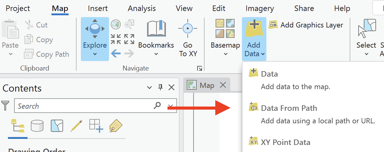
From the Map tab, select Add Data, and then select Data from Path
1.
-
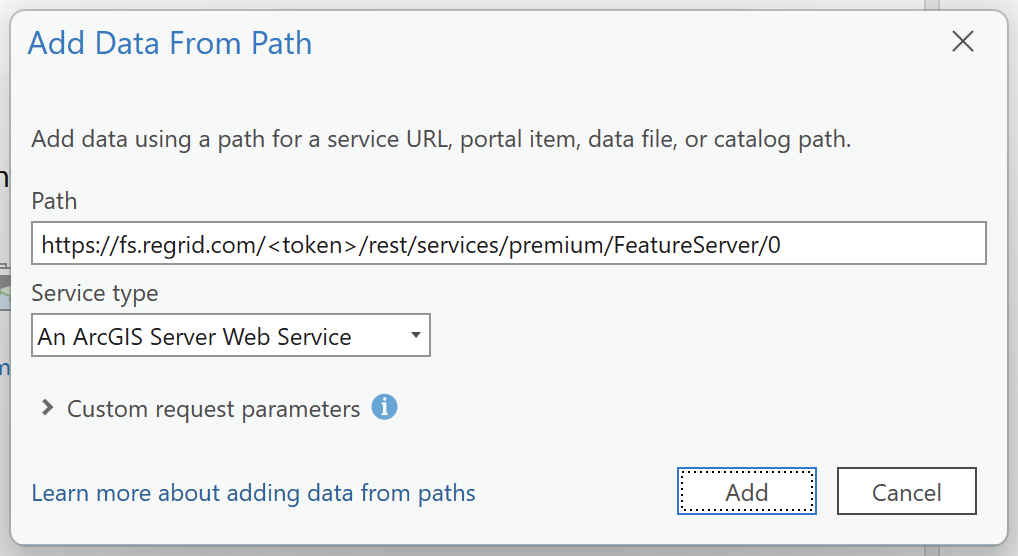
Paste the following URL into the Path field, replacing
<token>with your Regrid API token:https://fs.regrid.com/<token>/rest/services/premium/FeatureServer/0-
-
Click Add
-
Parcels should be rendered on a new layer in the map view. "Regrid Parcel Data" should appear in the Contents pane.
Troubleshooting access problems
If you receive an error that says "We are unable to connect" or "Invalid Path", your network administrator may need to unblock access to our Feature Service. Please check with them to ensure the service can be accessed. This is common in managed ArcGIS Enterprise environments.
One way to check if the Fature Service is blocked is to load the same URL you paste into ArcGIS in your web browser. If the browser displays a message about the content being blocked, contact your administrator.
ArcGIS Online Map Viewer
Loading the Regrid Feature Service on ArcGIS Online Map Viewer
The Regrid Feature Service is loaded using an authenticated token that the Regrid team will provision for you. While it is possible to load the Feature Service with the URL containing the token inline, our default recommendation is to use the “Store Credentials” method, detailed below. This method keeps the token hidden and unexposed, ensuring data security.
Why would you want to proxy the URL?
Saving the credentials within an ArcGIS item allows a new arcgis.com URL to be used without exposing the Regrid authenticated token in the URL for added security. An AGOL Proxy URL is also essential to reference for all downstream ArcGIS Online uses like Experience Builder, or the ArcGIS Python API.
Please note Regrid Feature Service Terms of Use still apply.
Step-by-step instructions to load the feature service on AGOL (ArcGIS Online):**
-
Browse to ArcGIS Online and sign in
-
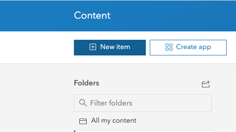
Select "Content" from the left nav
-
Select "New Item"
-
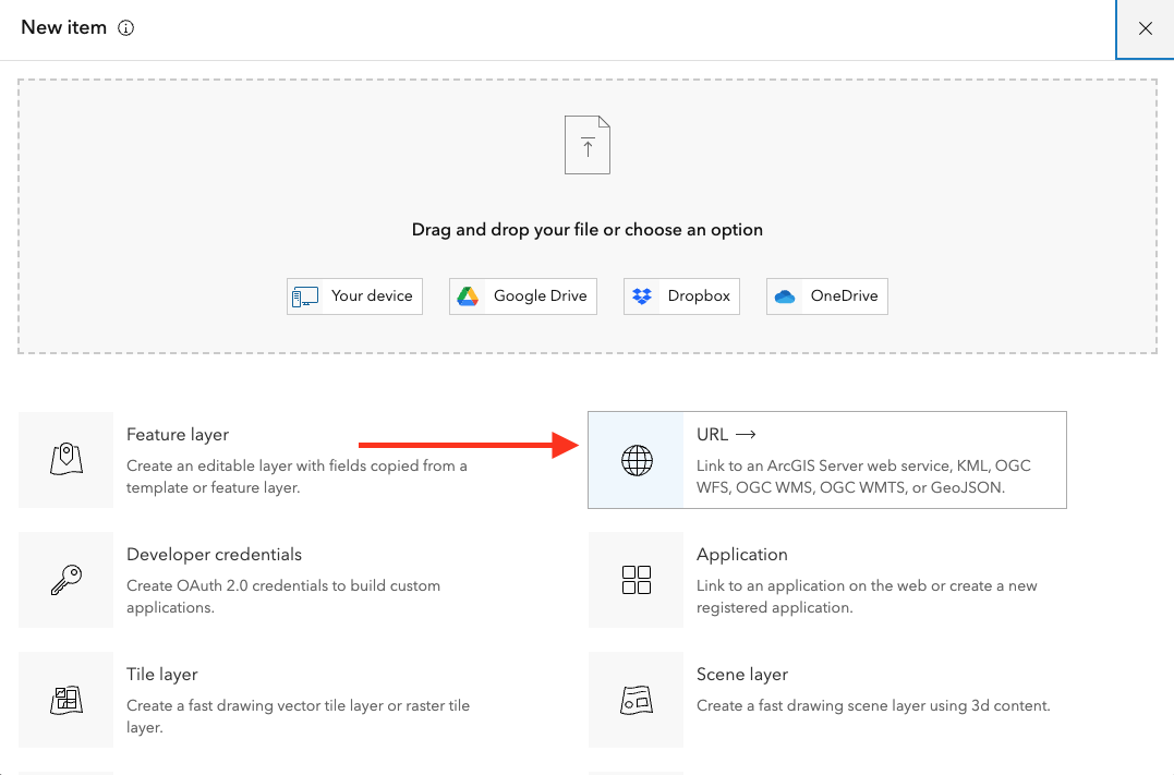
Select "URL"
-
Fill in this Feature Service URL to store the credentials within the Item and have the URL proxied by arcgis.com
https://fs.regrid.com/regrid/rest/services/premium/FeatureServer/0- Use the unique two letter country code in place of "premium" for international parcels.
https://fs.regrid.com/regrid/rest/services/CA/FeatureServer/0
-
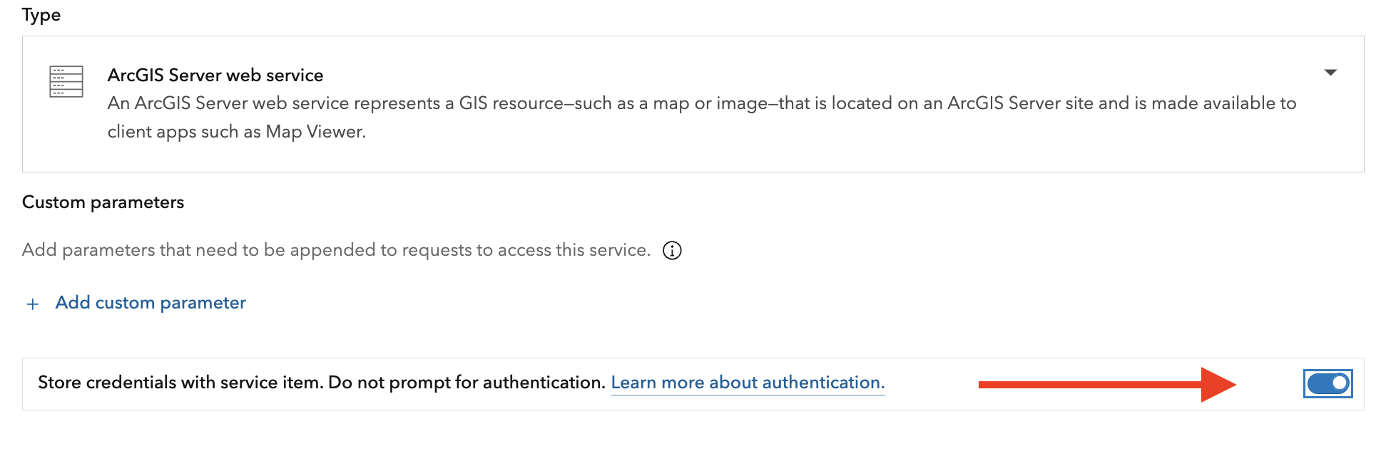
At the bottom of the New Item view enable "Store credentials with service item".
- To proxy the feature service URL, enable this option.
-
-
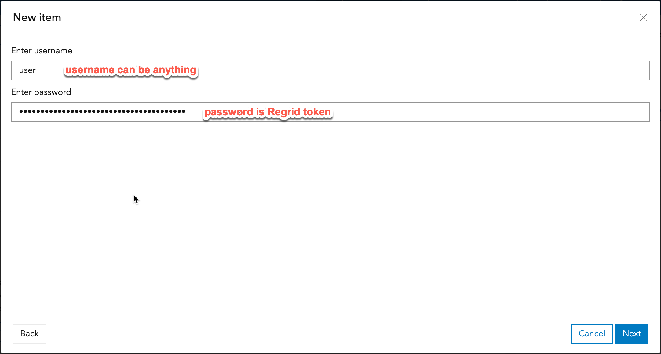
Select Next and follow the prompts to add your regrid token to the password field. The username can be anything.
-
Select Next and follow the prompts
-
Update the title to a name of your choosing like, "parcels"
-
The Regrid feature layer is now added as an item.
-
Use the Regrid layer: Select "Open in Map Viewer" in the upper right, to view your layer in a map.
-
Use the Regrid layer in existing maps:
- Select the "Layers" tab on the left
- Select the
+button next to the Regrid Feature Service layer - "Browse Layers" to find this newly created item and to add it to the map.
Matched Datasets with ArcGIS Online
If you have Matched Datasets on your account, and would like to view those relationships alongside the parcel layer with a proxied arcgis.com URL:
- Follow the steps above replacing the Regrid Feature Server URL with the base endpoint (excluding the layer id of 0). This will load all Regrid layers and their associated relationships as one item.
https://fs.regrid.com/regrid/rest/services/premium/FeatureServer
- Continue with the instructions above.
- Finally to view all related layers and tables, select "Open in Map Viewer" in the upper right.
Using our feature layer in other ArcGIS tools and apps
- From a map view, with a layer already added to the map, select "Save and open" from the left column, then "Save as".
- Enter a Title and Summary
- Select "Save map"
Data and Token Security
Data and token security is of utmost importance to us and we want to ensure that all of your data is secure and unexposed as well. So we recommend the following best practices when working with the Regrid data in AGOL:
- Ensure that your map and layer settings are private to you and your teams/organizations. Layers that are publicly available to all AGOL users and non-users can expose both the data and the token.
- This is why we recommend the store credentials method to hide and secure the token in your map layers.
- When working with tokens, we recommend rotating/switching tokens every quarter, as part of your data hygiene process. You can do so yourself by following the instructions here on your Regrid account dashboard or let the Regrid team know at [email protected] and we will be happy to generate the new token. Once you are operational on the new token, the older token will be disabled and retired.
ArcGIS API
We have a basic demo exercising ArcGIS API for Javascript.
- Save this HTML demo file to your computer for editing in your preferred code text editor:
- Download SDK Demo
- Log in to get an API key from ArcGIS at https://developers.arcgis.com/dashboard
- Replace
REGRID_API_KEYin the recently downloaded arcgis-sdk-demo.html file with an API key from the Regrid dashboard. The URL where you will add the key looks like this:https://fs.regrid.com/REGRID_API_KEY/rest/services/premium/FeatureServer/0
Updated 3 months ago