
Regrid Data Toolboxes for ArcGIS Pro
Quick Start Guide: A collection of custom ArcPy geoprocessing tools designed to scale and simplify high-volume parcel analysis with the Regrid Feature Service in ArcGIS Pro.
Welcome to the support page for the Regrid Parcel Data Toolboxes, designed for Regrid Feature Service (FS) customers to streamline and scale up parcel data operations in ArcGIS Pro. These toolboxes were built to support FS customers with their large-scale data analyses in ArcGIS Pro. This library of tools will expand as more use-cases are identified and incorporated.
The toolboxes allow you to efficiently complete large-scale analyses (multi-state or nationwide) by intelligently handling the technical constraints and query limits of high-volume geoprocessing.
Download & Installation
The Regrid Data Toolboxes are provided as standalone Python Toolbox (.pyt) files for easy integration within ArcGIS Pro.
Prerequisites
- ArcGIS Pro 3.4.2 or higher
- Access to the Regrid Feature Service
Download
| Toolbox Name | Description | Download Request |
|---|---|---|
| Regrid Parcel Data Toolbox | Tools for core parcel tasks (ll_uuid matching, GEOID-based spatial selections, study area extraction) | Request these tools by contacting your Customer Success Manager |
| Regrid Add-on Data Toolbox | Tools for Regrid Premium Add-on datasets (e.g. Standardized Zoning JSON Parsing) | Request these tools by contacting your Customer Success Manager |
Installation
-
Save the files
Download the
.pytfile(s) and save them to a permanent local folder (e.g.,C:\Regrid_Toolboxes) -
Open ArcGIS Pro
-
Click on Insert tab from Catalog pane
-
Add Toolbox
From the Insert tab, click
Toolboxes>Add Toolbox. -
Browse to file
Navigate to the folder where you saved the
.pytfile and select it. -
Confirm
The toolbox (e.g., Regrid Parcel Data Toolbox) will now appear under Project Toolboxes and is ready for use.
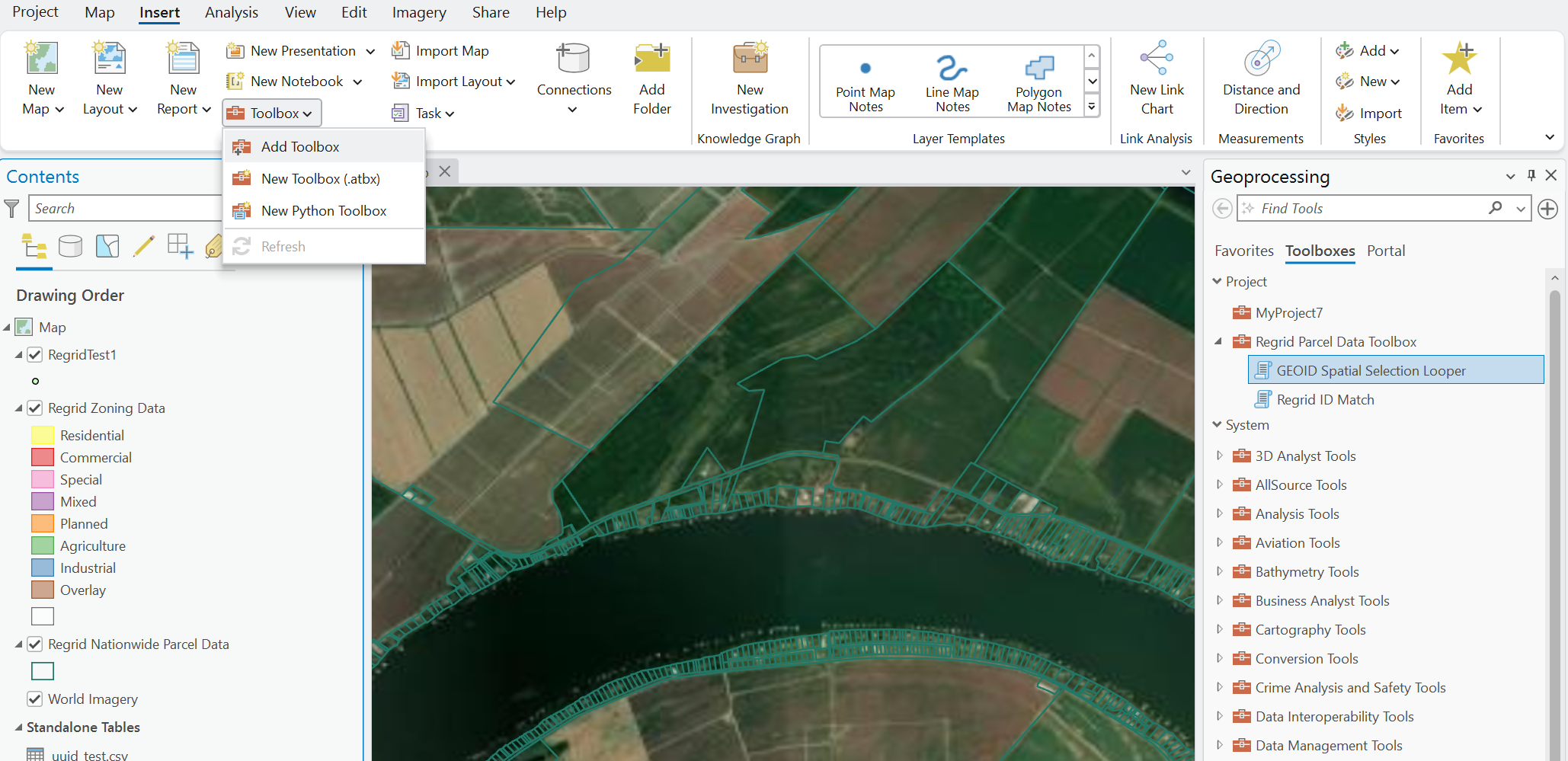
How to Add Toolbox in ArcGIS Pro
Tools Overview
Problem Solved: Scalability in ArcGIS Pro
ArcGIS Pro can struggle with the scale of Regrid's nationwide Feature Service (millions of polygon records). These toolboxes apply:
- Data chunking
- FIPS or region-based iteration
- Efficient filtering
to help you avoid server timeouts, overloaded queries and manual scripting.
Regrid Data Tool Index & Use Cases
| Tool Name | When to Use It | Problem Solved |
|---|---|---|
| GEOID Spatial Selection Looper | You want to spatially select parcels using an input point or polygon layer that spans many counties or states | Requests with the ArcGIS Pro native Select By Location tool fail due to size or volume |
| Regrid ID Match | You have a CSV of Regrid IDs (ll_uuid) and need to extract those parcels | Requests with ArcGIS Pro native Export Table tool fail due to server load |
| Regrid Spatial Chunker | You have a study area (e.g., a HUC8 watershed, a burn area polygon) that spans multiple counties and you need to extract all parcels within this boundary for local analysis. | Requests to Export Featuresfail due to high volume server load |
Tool Instructions
GEOID Spatial Selection Looper
Select parcels by spatial relationship across multiple counties by iterating on the GEOID (FIPS Code).
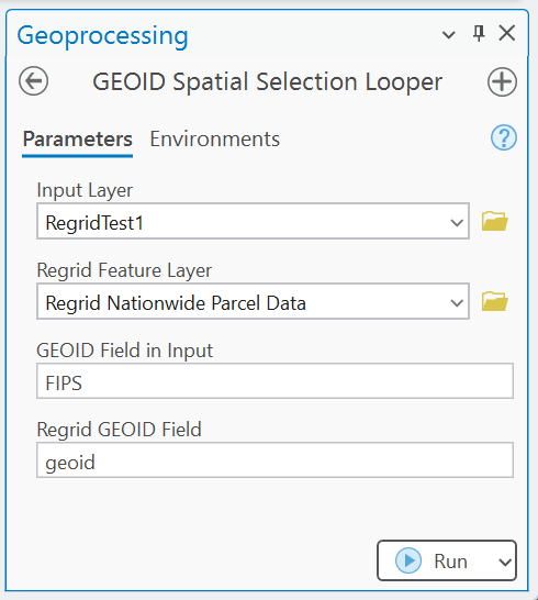
GEOID Spatial Selection Looper form in ArcGIS Pro
Parameters
| Parameter | Input Type | Guidance |
|---|---|---|
| Input Layer | Feature Layer | The features (polygons or points) you're using to select parcels |
| Regrid Feature Layer | Feature Layer | The live Regrid parcel Feature Service |
| GEOID Field in Input | Text (Required) | Can be any field name in your layer with county GEOIDs (e.g., FIPS, FIPS_CODE, GEOID10) |
| Regrid GEOID Field | Text (Fixed) | Always geoid |
Workflow
- Ensure both layers (Input Layer and Regrid Feature Layer) are added to your map.
- Run GEOID Spatial Selection Looper from the Parcel Toolbox.
- The tool will detect, filter, and perform a spatial selection for each GEOID.
- Output is a single feature class with all intersecting results merged and added to your map.
Errors and Troubleshooting Tips
- GEOID Field in Input must be appended if it does not already exist in your dataset. The tool relies on this input for iteration and will not work without it
- Because the tool is batching county requests, it may run for a long time if a lot of counties are included in the input dataset.
- The tool may be forced to skip parcel-dense counties (e.g., Cook County, IL) due to the high volume of data. If this occurs, you should process those counties separately by setting Esri's processing extent under Environments and use the Regrid tool for all other input locations.
Regrid ID Match
Efficiently match a large list of Regrid UUIDs from a .csv to parcels in the Feature Service.
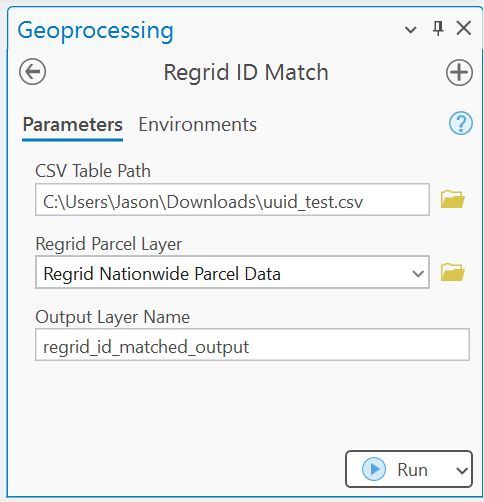
Regrid ID Match form in ArcGIS Pro
Parameters
| Parameter | Input Type | Guidance |
|---|---|---|
.csv path | File .csv) | .csv file with a column named ll_uuid |
| Regrid Parcel Layer | Feature Layer | Use dropdown menu to select the Regrid Feature Service layer already added to your map |
| Output Layer Name | User defined | Name the table to be outputted to your map |
Workflow
- Load the Regrid Parcel Feature Service into your ArcGIS Pro map.
- Launch Regrid ID Match from the Regrid Parcel Data Toolbox.
- Provide the required inputs and click Run.
- The tool will validate and process in batches of 1,000 UUIDs.
- Output will be added to your map, any failed matches will be reported in the messages panel.
Errors and Troubleshooting Tips
- The tool requires the input CSV to have a column labeled ll_uuid
- Invalid IDs will be automatically skipped and logged in the error output message
- This tool has been tested and validated with an input CSV list as big as 460,000
Regrid Spatial Chunker
Export a large study-area from the Feature Service to your local scratch space for deep analysis.
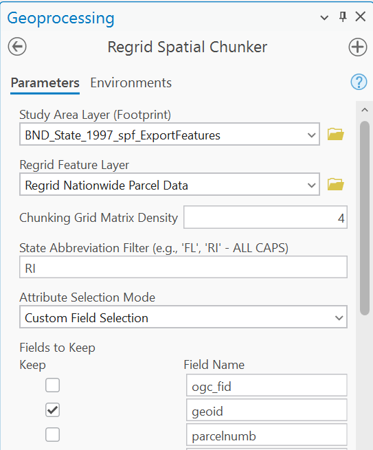
Regrid Spatial Chunker form in ArcGIS Pro
| Parameter | Input Type | Guidance |
|---|---|---|
| Study Area Layer (Footprint) | Feature Layer | A polygon boundary representing your area of interest |
| Regrid Feature Layer | Feature Layer | The Regrid Feature Service |
| Chunking Grid Matrix Density | Custom Input | An integer representing the rows and columns to be created over the study area envelope. Each bounding box becomes a server request. For small areas use 4, medium use 8, and in large areas use 16. |
| State Abbreviation Filter | Custom Input (Optional) | The two-letter state abbreviation if your study area is exclusive to a single state (this request is made server side and can speed up data transfer) |
| Attribute Selection Mode | Custom Selection | Keep All Fields or Custom Field Selection. Keep All Fields preserves the full attribute schema. Custom Field Selection is available to choose only those attributes that are essential to your workflow and to speed up the data transfer request. Note that in Custom Field Selection some core structural fields (i.e., ObjectID, SHAPE, FID)will be permanently checked to ensure minimum data validity. |
Workflow
- Ensure that your
Study Area Footprintis inEPSG:4326 - If using a definition query to limit to a single boundary within a multi-polygon set, the entire spatial extent of the original file is still passed to the sever. Because of this, best practice is to export the individual boundary as its own file and input this as your
Study Area Footprint. - Select Your Grid Density Strategically: Density
4(4*4 =16 cells): Ideal for small, isolated projects, counties, or smaller states (e.g., Rhode Island scale, ~450,000 parcels). Maximizes available bandwidth. Density8(8*8=64 cells): Ideal for medium-sized states or dense multi-county regional footprints (e.g., Massachusetts, Ohio). Density16(16*16=256 cells): Strictly required for mega-states or dense metropolitan regions (e.g., Florida scale, ~10,000,000+ parcels). Slices dense urban cores into stable, bite-sized data packets. Attribute Selection Modeoffers a dropdown check list. Customizing the attributes to your data needs will enhance data transfer speed.
Errors and Troubleshooting Tips
- If the tool fails due to timeouts, you may need to request at a higher
Chunking Grid Matrix Density - When requesting a large study area, the tool may run for an hour or more.
Regrid Add-on Data Tool Index & Use Case
This toolbox contains a tool designed for subscribers to Regrid's Premium Add-on Dataset: Standardized Zoning.
| Tool Name | When to Use It | Problem Solved |
|---|---|---|
| Standardized Zoning Add-on Parse JSON | You are subscribed to the Standardized Zoning Add-on dataset and want to find parcels that permit a specific land use (e.g., "retail") via permitted_land_uses JSON field | Manually parsing JSON attributes natively in ArcGIS Pro |
Standardized Zoning Add-on Parse JSON
Search Regrid’s Standardized Zoning Add-on for permitted land uses (e.g., “parking”) and return matching parcels.
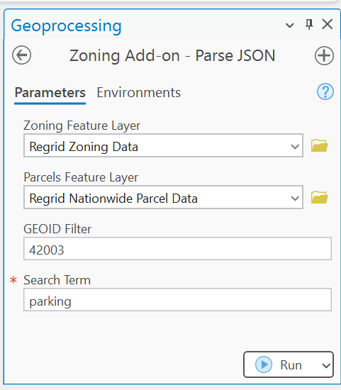
Standardized Zoning Add-on JSON Parse form in ArcGIS Pro
| Parameter | Input Type | Guidance |
|---|---|---|
| Standardized Zoning Feature Layer | Feature Layer | Standardized Zoning Add-on (contains permitted_land_uses JSON field) |
| Parcels Feature Layer | Feature Layer | Premium Regrid Parcel Layer (includes zoning_id and geoid) |
| GEOID Filter | Text | GEOID (FIPS code) for the county AOI (e.g., 42003) |
| Search Term | Text | Case-insensitive land-use keyword (e.g., parking) |
Workflow
- To run Parse JSON from the Regrid Add-on Toolbox.
- Enter the county GEOID and the land-use term.
- The tool will identify relevant zoning IDs matching your search, find parcels with those zoning IDs within the specified GEOID and output a parcel feature class containing the matched zoning IDs.
Errors and Troubleshooting Tips
- Input handles one GEOID and one search term per tool run
Feedback and Continuous Improvement
These toolboxes were built with customer feedback. If you are encountering frequent errors, or if you've built custom scripts you'd like to see automated—we want to hear from you.
Suggest a Tool or Report a Bug
Have an idea or issue?
Please include:
- Your email
- Example GEOID
- Problem description
- Suggested tool name or functionality
Reach us at [email protected]
Updated 5 months ago