USPS Data on the Regrid Platform & App
This feature is only available on the platform with a Regrid Pro or Team account. Click here to upgrade your account.
USPS Data - How to
If you’re a Pro or Team member of regrid.com you now have an easy way to see all residential parcels, nationwide, as well as an indicator of vacancy across all parcels that have structures. Read more about this dataset, and its potential limitations, here.
For a visual overview of our USPS data, click here.
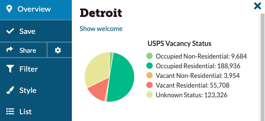
Overview Panel
The overview panel on the map UI will give you a quick snapshot into your location’s vacancy status based on the USPS data attached to the parcels in the area.
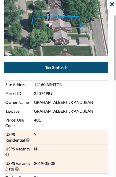
Parcel Lookup
Looking up parcels got even better now. With our premium USPS fields, you can quickly look up parcels of interest and find their residential & vacancy status in a matter of minutes.
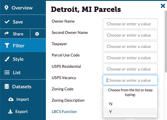
Filter & Style
You will be able to filter & style USPS residential & vacancy fields to get deeper insights into your location. Find out how many parcels are vacant in your focus area or neighborhood! All you have to do is go to the filter function, enter Y or N into the ‘USPS Vacancy’ field, and you will be able to see the associated parcels visualize on the map. You can also do the same thing from the Style tab, if you want to color code beyond Filter’s default purple.
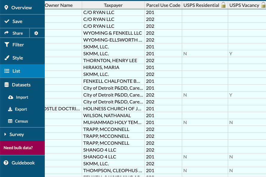
Export USPS Data
Enterprise customers can export up to 50,000 rows of USPS data in CSV (spreadsheet) format. However, for bulk data downloads and shapefiles, you will need to license our parcel data separately.
CSV exports of the USPS columns are not available for Pro customers.
Load and View USPS Data on the Regrid App
For those of you who work on tracking and addressing vacant properties in your city, you’ll likely want to take this USPS data into the field and view it in our app - here’s how! (Note: you can follow these same steps with any Style-able field to be able to see them on the app, though this example is USPS).
-
From the website, create a new Project. You’ll use this Project to visualize the USPS data, and once you’re collecting survey data, that will be attached to this Project as well.
-
Under Style tab, click “Add a Rule”. In the first box, click the dropdown menu and navigate to ‘usps_vacancy’.
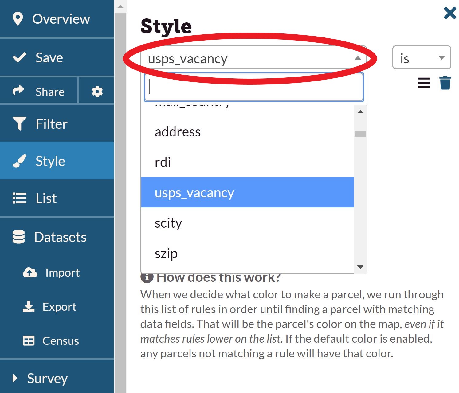
In the slightly smaller dropdown box below this one, click the dropdown and select ‘Y’. To the right of that box is the color that will represent vacancy - click and use the color picker to choose the one you want.
-
Click ‘Apply’. Properties marked as USPS vacant should visualize on the map. Click ‘Save’ on the sidebar to save your project as it is currently.
-
On the left hand sidebar, click ‘Survey’, then ‘Editor’. This is where you can create your survey questions - see our Guidebook page for more on this. If you are mostly just interested in viewing properties and/or checking if they really do look vacant, all you may need is one question, something like “Does this property look vacant?” with answers “yes” and “no”.
-
When your survey is how you want it, click ‘save’ at the bottom of the survey editor. This will save your questions - then click ‘Save’ on the sidebar to make sure that the Project as a whole is saved correctly.
-
Log in to the Regrid app. Your username and password will be the same as what you use to get into the website.
-
Tap ‘Choose a Survey’ and select the Project that you’ve just created. You may need to refresh this page before it shows up.
-
Voila! You should now be able to see the properties marked ‘USPS Vacant’ showing up on your map in the color you chose back in Step 2.