Export Data
This feature is only available with a Regrid Pro or Team account. Click here to upgrade your account.
Note: this feature is only available from the web portion of the Regrid Property App (app.regrid.com), not via the mobile app.
Getting Started with Export
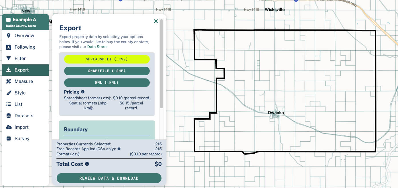
First, click on the Export tab in the left hand toolbar.
Then, choose your format (see the 'Export File Formats' section below to learn more about format types and what's best for you).
Getting just the properties you want
Because the export setup is priced per-parcel, you'll likely want to narrow down your results to just properties you care about before you export. There are two main ways to do this:
-
By geography. You can use the Bounds dropdown to select a smaller geographic area, such as a census tract or a neighborhood; you could also draw a custom Focus Area.
-
By using our Filter tool. This will let you narrow down to properties of certain types, for example a certain acreage, owner, or land use.
Export File Formats
Currently, we support exports of Spreadsheet(.csv), Shapefile(.shp), and KML(.kml) files.
Spreadsheet(.csv): This is the format to choose if you want to open your data in a spreadsheet software, like Excel or Google Sheets, etc.
Shapefile(.shp): This is GIS software maker ESRI's native format and usable in most GIS softwares, including the ESRI suite (ArcGIS Pro, ArcGIS Online, etc). If your goal is to pull our data into another mapping software, this is the format we recommend.
KML(.kml): This is the file format to use if you want to import your file into Google Earth. Note: We have found that KMLs can have a hard time dealing with large files, so recommend that users who want to do big exports (greater than ~50,000 parcels or so) use an alternate format like shapefile for best results.
Pricing
We price spreadsheet records at 10 cents per parcel, and spatial formats (shp and kml) at 15 cents per parcel.
Users get 5,000 spreadsheet (CSV) records per month free as part of their subscription. You can check your usage of these free downloads from your Data Orders tab, which can be found below your list of exports.
While the free limit is 5,000 per month, users can download any number of properties - once you've used your 5k free allocation for the month, you'll simply pay the flat per-parcel pricing for additional parcels' data.

Export Tutorial Video
Exporting Your Own Data
In cases where you've created or imported data to Regrid (for example, if you have used our Import tool, or if you have been surveying or following properties), you'll see a toggle show up on the Export tab: Only My Data/All Data.

'Only My Data' toggle
If the toggle is on 'My Data', an export will result in a file with just properties that have your data attached within the current geography of your project.
Example: You have followed 15 properties in Miami, and want to export those 15 properties as a shapefile. You'd want the toggle set to 'My Data', so that your export results in just those 15.
'All Data' toggle
If the toggle is on 'All Data', the export will function just as it would if you did not have any datasets attached - although any properties in your selection that have an attached dataset will have your data in them as well.
Example: You have imported a spreadsheet of 1,000 foreclosed properties of interest to a Project for context, but you want to find and export all properties that have commercial zoning. Here, you'd change the toggle to 'All Data' to get the desired result.
Using Exported Files in AutoCAD or other Engineering Software
If you're looking to bring Regrid's data into AutoCAD once you've exported it, you'll need to use the SHP format, then utilize a plugin or standalone GIS software that can translate the SHP into DWG (.dwg) format. Three recommended options are:
-
The open-source QGIS is a great, user-friendly option. You can open your KML or SHP file in QGIS, export it as a DXF file, and then open that DXF in AutoCAD to save it as a DWG. It’s a quick and reliable way to get your data into a DWG format.
-
If you have access to ArcGIS, the process is even simpler. Just import your KML or SHP file and use the "Export to CAD" tool, which will allow you to directly export your data as a DWG file. It’s designed for this kind of task and works seamlessly.
-
The Spatial Manager plugin within AutoCAD should allow you to directly import SHP and KML files into a DWG format.
Looking for Bulk Parcel Data?
Interested in data at a larger scale? We offer downloads in a variety of formats and geographies.
If you want to buy our data by the county or state, our Data Store is the place to start. Or, if you want to discuss licensing Regrid's nationwide parcel data, click here.