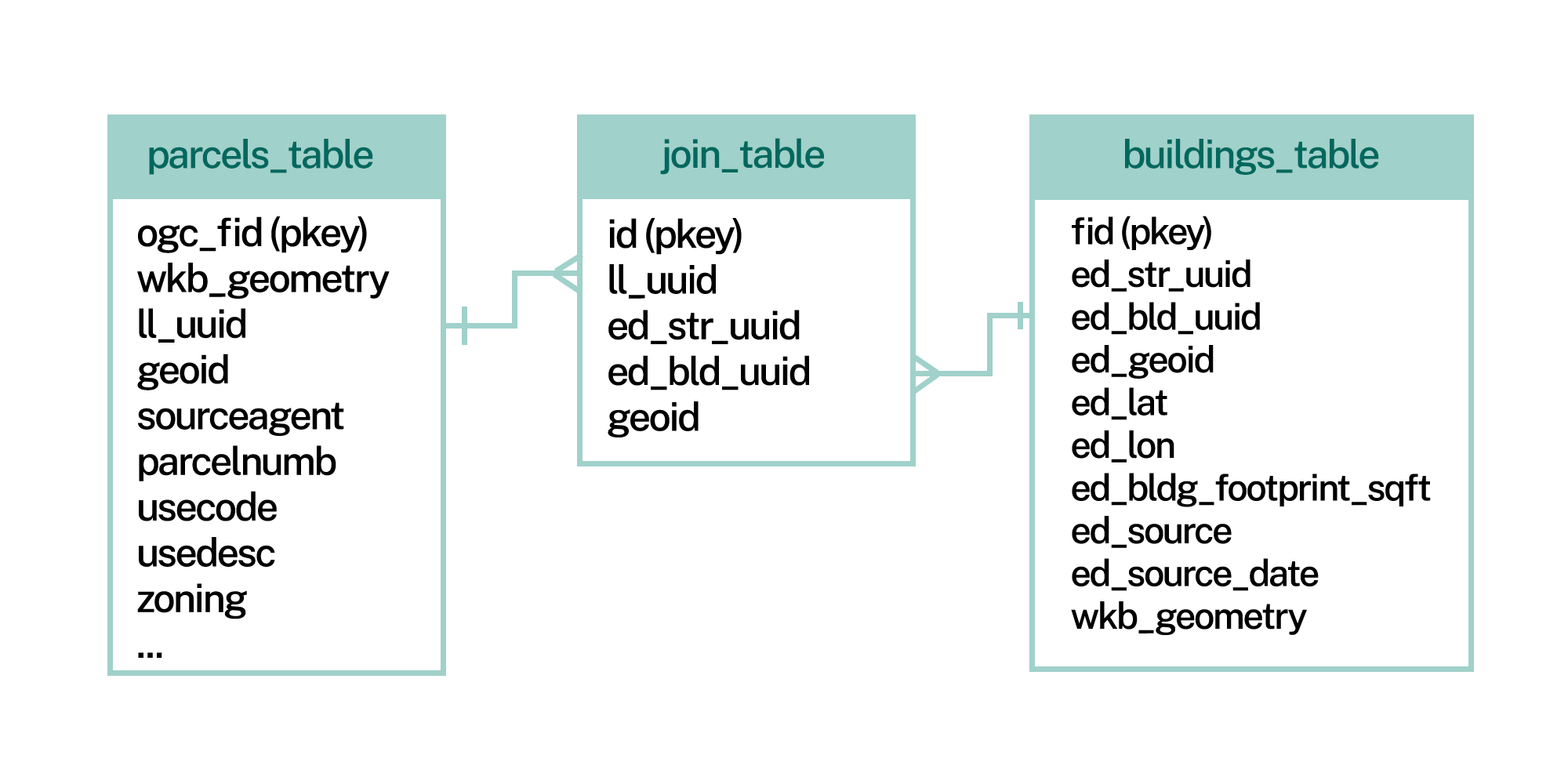
Matched Building Footprints Schema
With the Matched Building Footprints Add-on, you get our nationwide parcel data with premium schema attributes, plus buildings data that follows this schema.
Regrid Matched Building Footprints
This file contains the building shapes plus associated attributes. An additional join file, described below, includes the building to parcel matches.
| Field | Description | Datatype | Example |
|---|---|---|---|
| ed_str_uuid | Universally Unique ID of the entire structure | text | 460ec73d-a847-11eb-b9dd-a0369f4d4bda |
| ed_bld_uuid | Universal Unique ID of the building extracted from the structure | text | f51e780a-9f4e-11eb-8ac7-d89d67c66f28 |
| ed_geoid | County FIPS code | text | 01001 |
| ed_largest | An indicator of the largest building on a parcel | numeric | 1 or NULL |
| ed_lat | Latitude of a point in the shape, typically the centroid | numeric | 25.798749 |
| ed_lon | Longitude of a point in the shape, typically the centroid | numeric | -80.339941 |
| ed_bldg_footprint_sqft | Building footprint area in square feet | numeric | 24052 |
| ed_source | Source of the building footprint | text | Aerial Imagery |
| ed_source_date | Date of the building source imagery formatted as MM/DD/YYYY | text | 11/26/2020 |
| wkt | Building geometry in Well Known Text (wkt) format | text | POLYGON((-122.9279 40.7133, -122.9287 40.7136, -122.9287 40.7135, -122.9291 40.7131, -122.9279 40.7133)) |
Matched Building Footprints With Heights
This product includes all of the building footprint attributes above, and adds the following:
| Field | Description | Datatype | Example |
|---|---|---|---|
| ed_max_height | Maximum height of the structure in ft, excluding potential clutter like an antenna, overhanging tree, etc | numeric | 12 |
| ed_mean_height | Mean height of the structure in feet | numeric | 11.25 |
| ed_max_object_height | Maximum height of the structure in ft, including potential clutter like an antenna, overhanging tree, etc | numeric | 27.6 |
| ed_lag | Lowest Adjacent Grade, lowest observed ground elevation above sea level around the boundary of the building | numeric | 662.18 |
| ed_hag | Highest Adjacent Grade, highest observed ground elevation above sea level around the boundary of the building | numeric | 663.59 |
| ed_mean_elevation | Mean ground elevation in ft under the structure footprint | numeric | 662.64 |
| ed_mean_slope | Mean roof slope | integer | 7 |
| ed_stories | Estimated number of stories based on building height | integer | 7 |
| ed_gross_area | Estimated area of the building based on stories and square footage of the polygon | numeric | 2089.448 |
| ed_volume | Volume of the building based on square footage and the mean height of the polygon in cubic feet | numeric | 23506.29 |
Regrid Matched Building Footprints Join File
This flat file joins building IDs to parcel IDs per county. This diagram shows
the buildings join file can be used to match parcels by ll_uuid to buildings
by ed_bld_uuid:

| Field | Description | Datatype | Example |
|---|---|---|---|
| ll_uuid | Uniquely identifies a single parcel | uuid | 03e304ad-4d2c-451e-ac90-0d9aa0b46dc0 |
| ed_str_uuid | Universally Unique ID of the entire structure | text | 460ec73d-a847-11eb-b9dd-a0369f4d4bda |
| ed_bld_uuid | Universal Unique ID of the building extracted from the structure | text | f51e780a-9f4e-11eb-8ac7-d89d67c66f28 |
| geoid | County FIPS code | text | 01001 |