Using Parcels + Matched & Add-on Datasets
Regrid’s Esri-compatible Feature Service allows you to use Regrid’s seamless nationwide parcel layer in Esri tools.
Learn how to incorporate both the base parcel data and the additional matched & parcel add-on data layers through the Regrid Feature Service.
Parcels + Matched Data Layers
In addition to Regrid's Nationwide Parcels, your license may include access to one or more of our premium + matched or add-on datasets such as:
1: Matched Building Footprints and Matched Building Footprints with Heights (Feature Layer - Tabular + Spatial Data)3: Matched Secondary Addresses (Feature Layer - Tabular + Spatial Data)4: Enhanced Ownership (Tabular Data)5: Standardized Zoning (Feature Layer - Tabular + Spatial Data)
Please note that these are additional Feature Layers and Tables that can be added to your Esri stack, maps and applications along with our Nationwide Parcel Data Feature Layer.
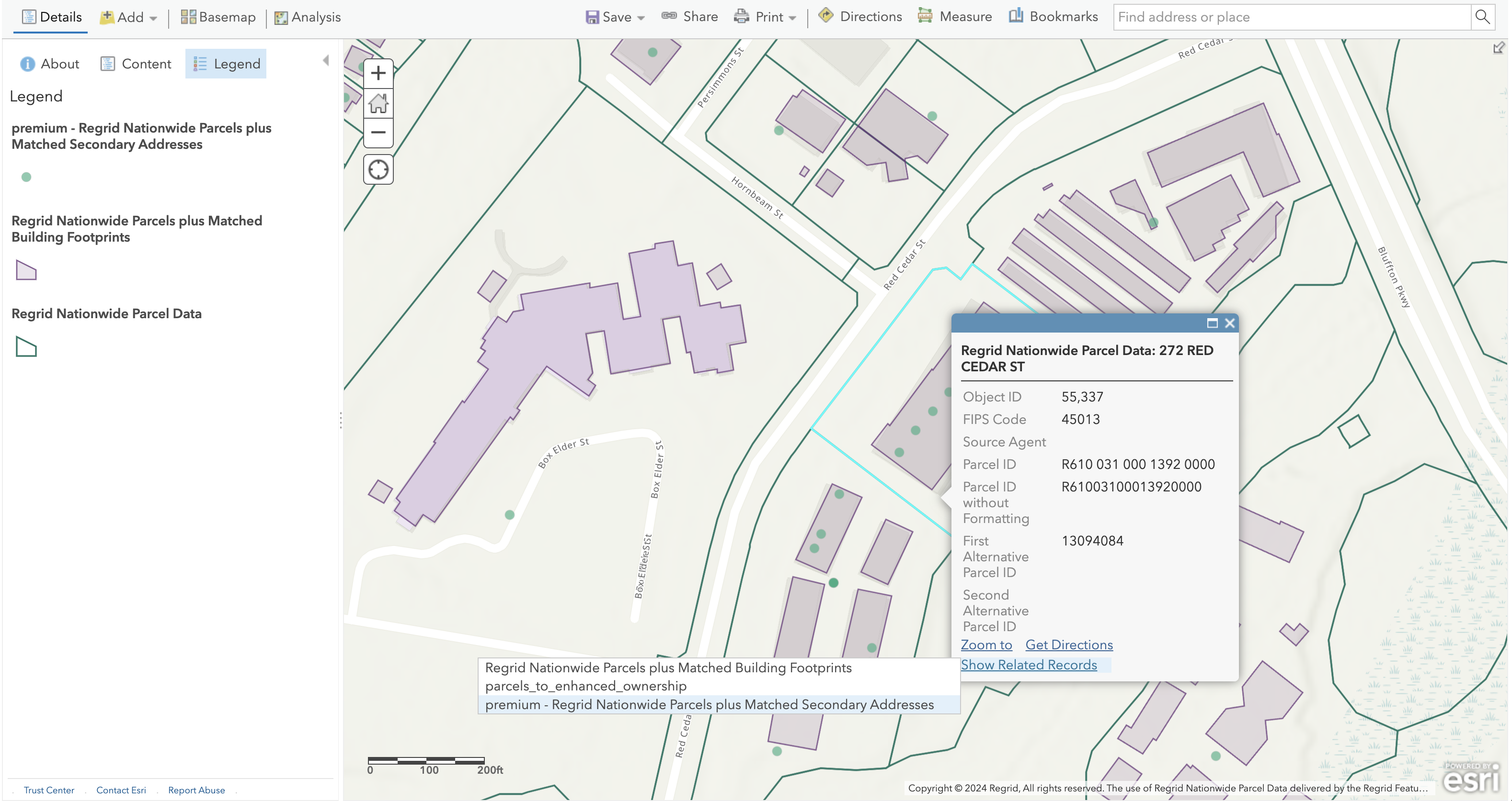
Each layer/table in Regrid's Feature Service is identified with a unique integer ID (Parcels is layer 0. The IDs for the matched datasets are shown in the list above). The Matched Datasets can be individually added to maps, applications, or your ArcGIS Online account as items by using the unique layer ID at the end of the Feature Service URL (i.e. https://fs.regrid.com/<token>/rest/services/premium/FeatureServer/1 would be the Matched Building Footprints layer).
Please note that each one of these layers are only available with our parcel data and are matched to the Regrid UUID. (ll_uuid).
Matched Building Footprints and With Heights
https://fs.regrid.com/<token>/rest/services/premium/FeatureServer/1
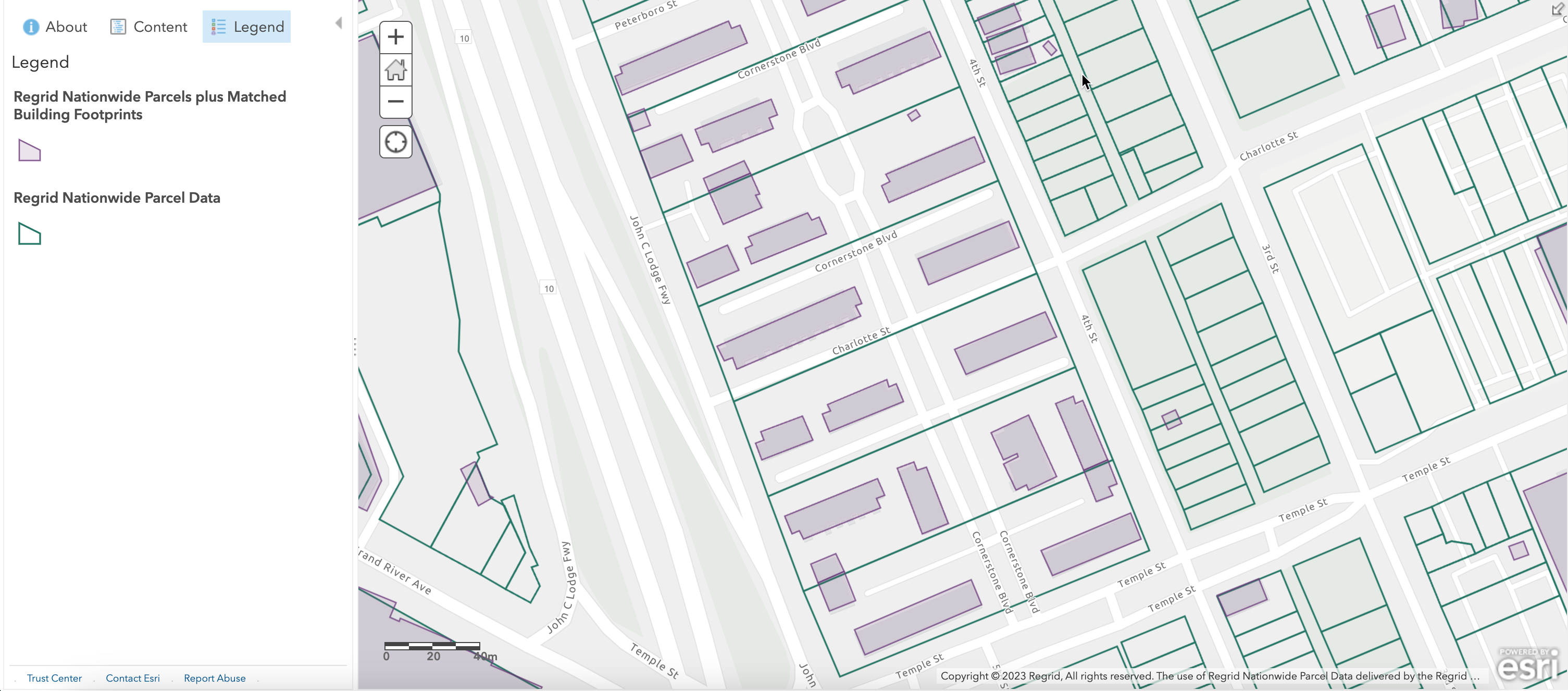
Matched Building Footprints contains more than 183 million building footprint geometries, derived from aerial imagery & LIDAR data, and matched to Regrid Nationwide Parcel Data.
Matched Building Footprints is a spatial feature layer that can be added to ArcGIS maps and applications and for display and spatial analysis alongside the Regrid Nationwide Parcels layer. Since Regrid’s nationwide parcel data is delivered as the base feature layer for the Esri stack, the buildings feature layer is delivered as a separate feature layer that can only be accessed along with Regrid parcels.
The Regrid Feature Service includes a many-to-many relationship between the Parcels feature layer and Matched Building Footprints that helps establish the per-parcel record matching, so that users can access one or more building records directly from a selected parcel in both ArcGIS Pro and ArcGIS Online. See more in the Viewing Related Records section below for details. As a spatial layer, Matched Building Footprints can also participate in spatial joins with the Regrid Nationwide Parcels layer.
Matched Building Footprints with Height is an enhancement to the existing Matched Building Footprint Add-on and provides users with information related to the vertical nature of the buildings with items such as max, min, and median height, ground elevation(s), roof slope, and estimates based on the height of the building such as number of stories. These expanded with Height attributes were created through advanced techniques utilizing lidar. This vertical component provides users who need to understand the vertical component of buildings or how elevation variances and slope of roof inform and impact their business decisions.
Matched Secondary Addresses
https://fs.regrid.com/<token>/rest/services/premium/FeatureServer/3
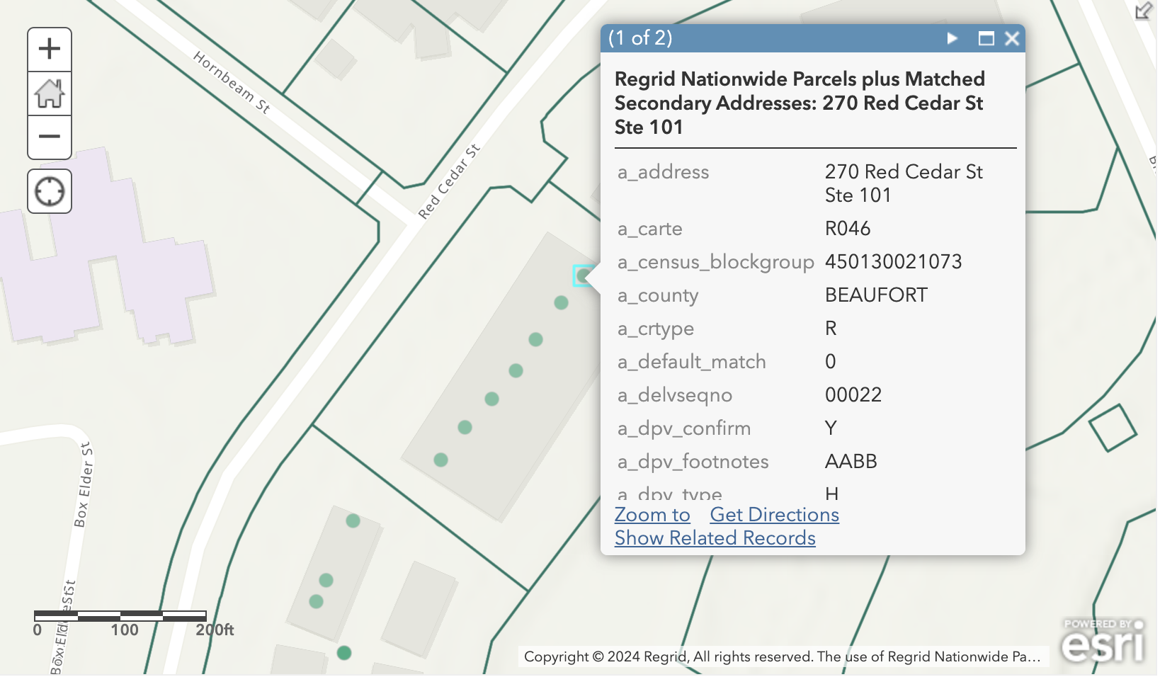
Regrid’s Matched Secondary Addresses solution also provides additional insights into more complicated property situations for both the residential and non-residential properties. This solution provides over 179 million addresses which have been standardized to USPS standards, presenting over 70 million validated addresses not currently available via Regrid’s nationwide parcel data.
Matched Secondary Addresses is a spatial dataset that is matched with Regrid Nationwide Parcel Data and hence is delivered as a points feature layer alongside the base parcel data feature layer that provides information about all matched addresses on a parcel. You can see address points matched to the parcels, including those that don't necessarily sit on a parcel too, like street addresses in our Matched Secondary Addresses feature layer. All known addresses nationwide are viewable through this layer.
The Regrid Feature Service includes a relationship between the parcel data feature layer and Matched Secondary Addresses dataset that helps establish the per-parcel record matching just like we do in our bulk files database, so that users can access one or more address records directly from a selected parcel in both ArcGIS Pro and ArcGIS Online. See more in the Viewing Related Records section below for details.
Enhanced Ownership
https://fs.regrid.com/<token>/rest/services/premium/FeatureServer/4
Regrid's Enhanced Ownership parcel data add-on solution provides standardized daily updates of ownership records and access to the most current ownership information available including numerous owner names (shared ownership), mailing addresses, and deed ownership information, matched at a parcel level with Regrid’s UUID.
Enhanced Ownership is also a non-spatial dataset that is matched with the Regrid Nationwide Parcel Data layer and hence is delivered as a non-spatial table. The Regrid Feature Service includes a relationship between the Parcels layer and Enhanced Ownership relationship that helps establish the per-parcel record matching just like we do in our bulk files database, so that users can access Enhanced Ownership attributes directly from a selected parcel in both ArcGIS Pro and ArcGIS Online. See more in the Viewing Related Records section below for details.
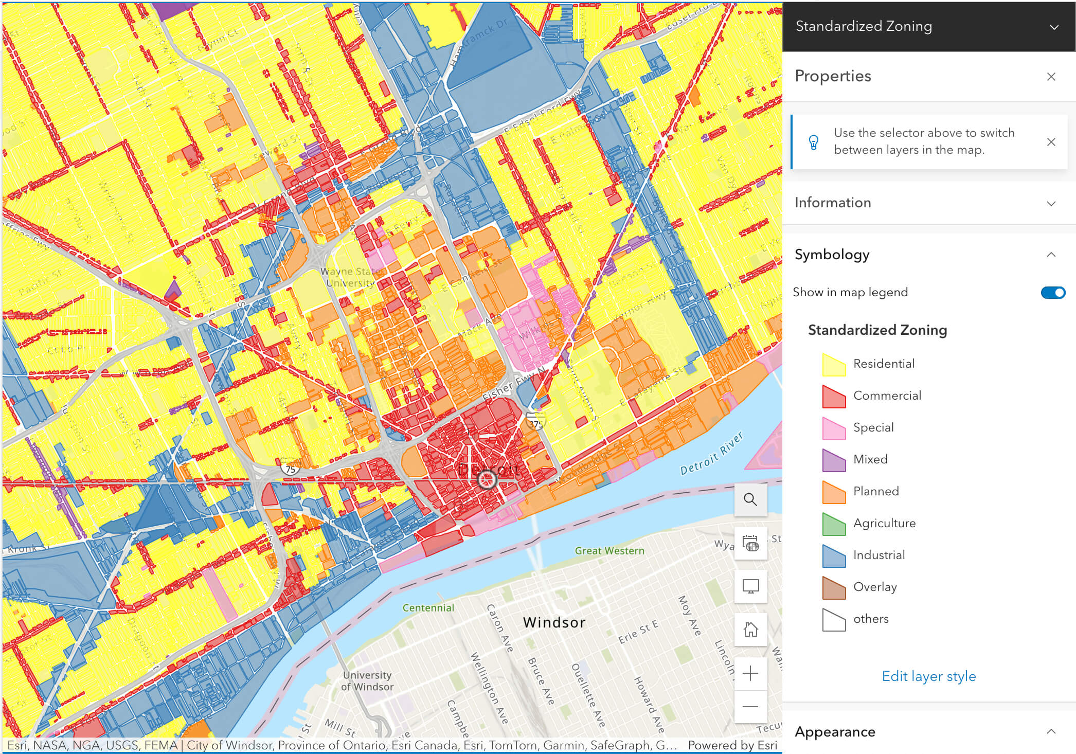
Standardized Zoning
https://fs.regrid.com/<token>/rest/services/premium/FeatureServer/5
Gaining deeper insights into permitted use of "land" just got easier with our industry leading Standardized Zoning data. As a spatial layer matched to Regrid’s nationwide parcel data, with standardized schemas, this product is available via bulk files, API and Feature Service. Standardized Zoning covers over 6,300 municipalities across the USA, and expanding. Granular attribution and ordinance details provide insights you need to understand permitted uses for land parcels to empower your use cases.
Containing rich attribution including not only zoning code, description and type, but getting granular into zoning sub-type, setback restrictions, Floor Area Ratio (FAR), and many more, including the all important link to the actual municipal ordinance to ensure full compliance in even the most complex situations. Leverage granular and standardized geospatial zoning data at scale with parcel level granularity and accelerate your time to action.
Viewing Related Records
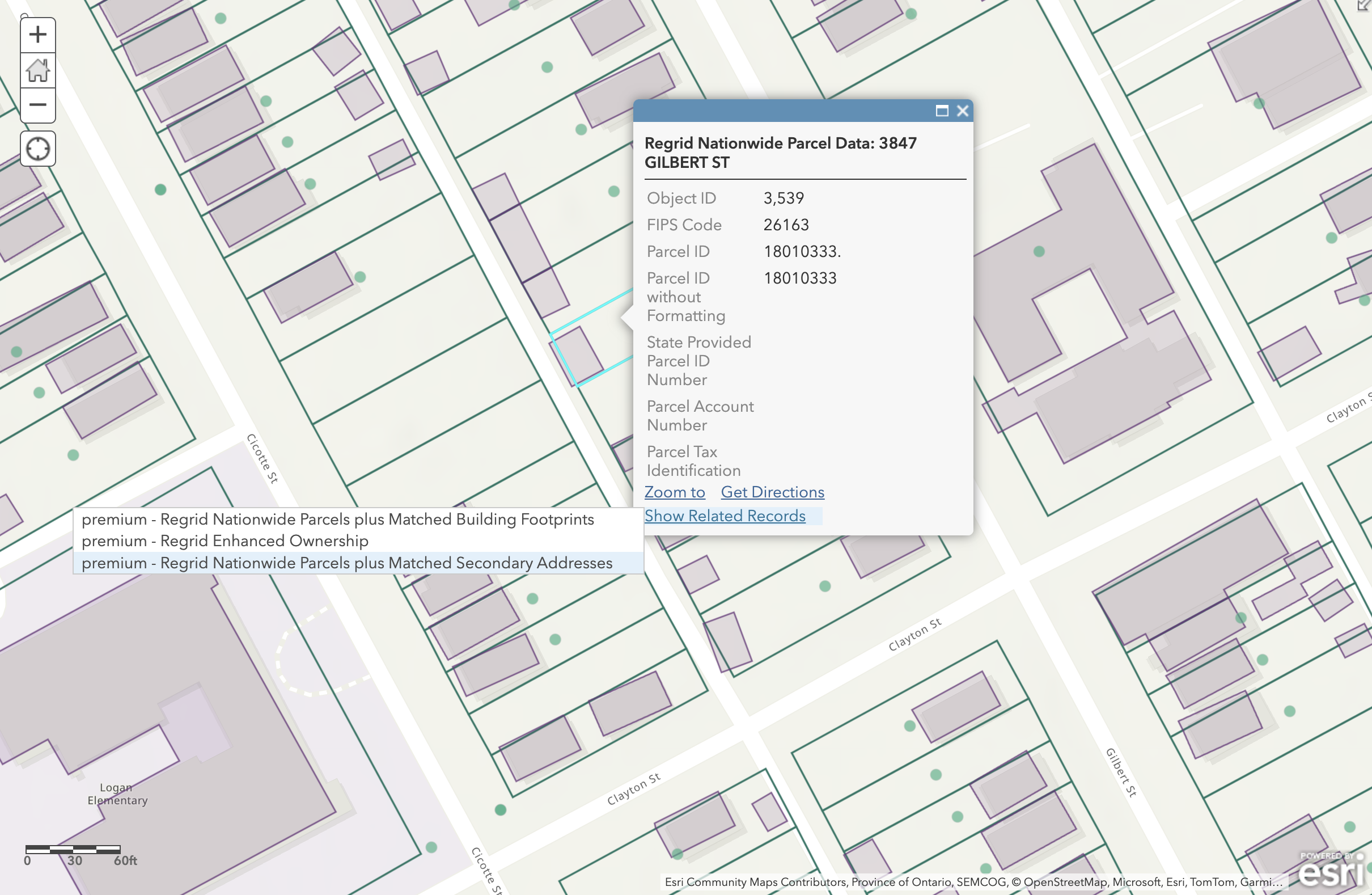
In ArcGIS products, Relationships contain information on how the attributes of two separate layers are linked based on a shared column. This information is made available to tools like ArcGIS Pro, ArcGIS Online, and the ArcGIS Maps SDKs. Relationships allow users to select a feature and easily access matching information associated records from other layers.
The Regrid Feature Service includes relationship definitions that connect the Nationwide Parcels to the Matched Datasets, allowing users to take advantage of these features without having to configure anything. See details on using related records for each supported platform below:
ArcGIS Online (Map Viewer Classic Only)
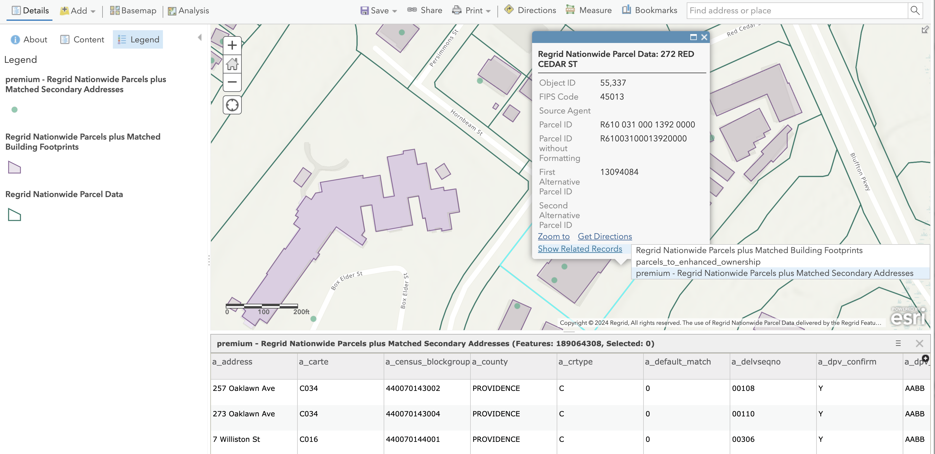
In order to access information about a related matched dataset in the ArcGIS Online Map Viewer Classic, first make sure that the map includes both the Parcels layer as well as the matched dataset (e.g. Matched Secondary Addresses). Next, navigate to a parcel of interest and click on it to display the popup for that parcel. At the bottom of the popup should be a link titled Show Related Records. Clicking on that will reveal a list of related layers. Clicking on the name of a related layer will open the Attribute Table and display the attributes of that parcel's related records for the selected layer. Remember, the related layer or table must be in the map in order for this feature to work.
Further information on the use of related data in ArcGIS Online maps can be found in Esri's documentation. Currently, support for viewing related records in Regrid's Feature Service is only available in the Map Viewer Classic interface. The newer Map Viewer application only recently rolled out support for viewing related records, but has not yet implemented the functionality for non-hosted feature services.
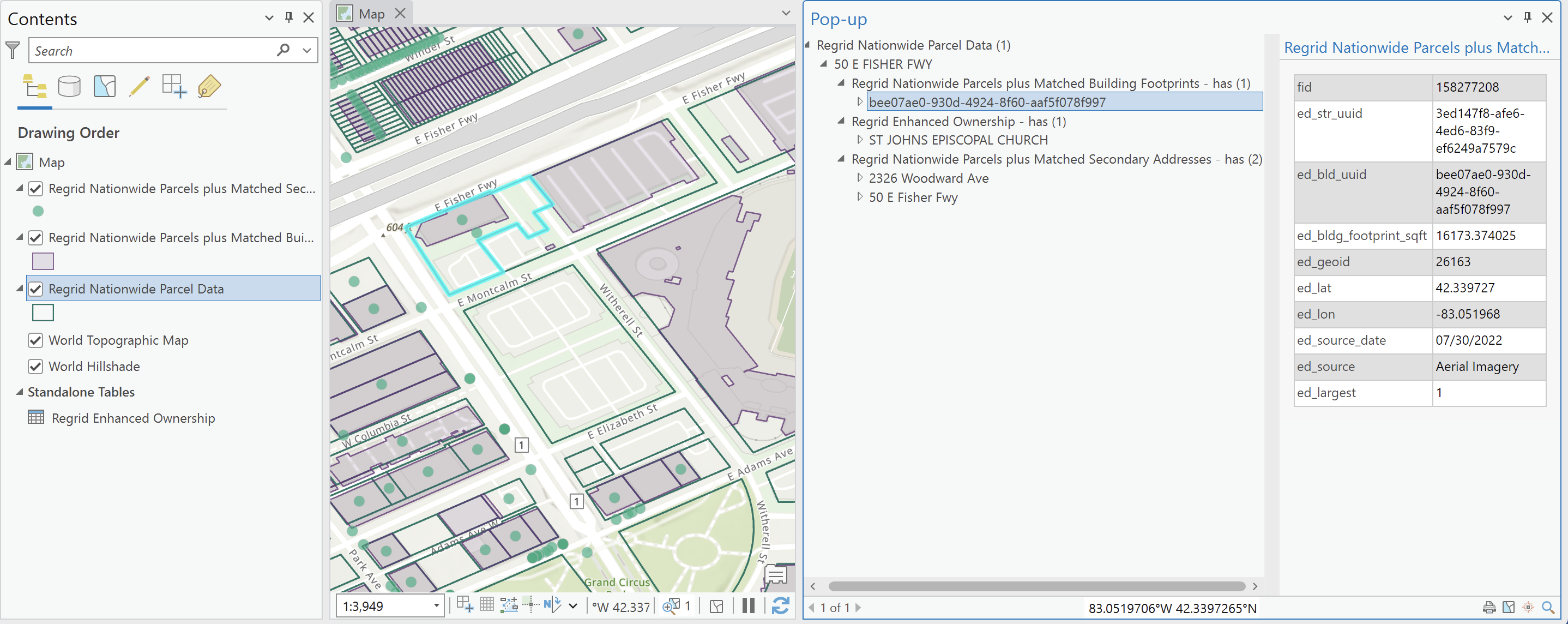
ArcGIS Pro
To access a parcel's related records in ArcGIS Pro, make sure that the Parcels layer is added to the map. It is not necessary for the Matched Dataset layer/table to also be present in the map — if a related layer or table is not in the map, you can still view its data. First select a parcel on the map. ArcGIS Pro provides several options for viewing related data: Popups, the Attribute Pane, and the Attribute Table. For more on accessing related records in ArcGIS Pro, see this article from Esri.
ArcGIS APIs and SDKs
The Regrid Feature Service is compatible with the Maps SDK for Javascript as well as the ArcGIS API for Python, both of which include methods for accessing related records. The Maps SDK for Javascript includes a method on Feature Layers called queryRelatedFeatures. The ArcGIS API for Python includes a similar method for feature layers— query_related_records. In both cases, you must provide one or more objectIds from the Parcel layer, the id of the relationship, and a list of desired fields from the related layer or table.